
SCIENCE
Nabta Playa: Egypt’s Ancient Stone Circle and Solstice Mark
Nabta Playa is a dry lake basin in southern Egypt. Its small stone circle marks summer solstice sunrise, and the proposed star lines stay unproven.

Nabta Playa is the stone circle often called Egypt’s oldest observatory, set in a dry lake basin in the Nubian Desert. The ring is one piece of a much larger Neolithic camp and ritual ground.
Herders came when summer rain filled the lake, dug wells, and buried cattle with great care. They also stood a small ring of sandstone slabs toward sunrise on the summer solstice. Lines from the bigger stones toward bright stars are still argued, and this page sorts the basin, the circle, the cattle, and the museum where the stones stand now.
The Nabta Playa Basin in the Nubian Desert
Nabta Playa was a playa, a closed basin that held a temporary lake and had no river outlet to the sea. It sits in the Nubian Desert of southern Egypt, about 800 kilometers south of modern Cairo, on sand that looks empty until you picture the old shoreline.
The basin lies about 100 kilometers west of Abu Simbel, in the border country of southern Egypt. Abu Simbel is the cliff temple people already know. Nabta is the open ground far to its west, with no standing town on top of the sites.
The hollow is kidney-shaped, roughly 10 kilometers by 7 kilometers. Camps, graves, and stone lines are spread through that one drainage rather than crowded onto a single knoll, which is why a visit in the mind has to move from shore to shore.
The ground is bare desert now. In the early Holocene the African summer monsoon reached this latitude, and the basin held water only in season. Yearly rain then was no more than 100 to 150 millimeters, enough for Sahel grass, scattered trees, hares, and small gazelles.
A Bedouin guide, Eide Mariff, led Fred Wendorf to the standing stones in 1973. Wendorf and the Polish archaeologist Romuald Schild spent years mapping dozens of sites around the old shore, from hearths on the dunes to settings of large stones.
When the monsoon later shifted south, the basin dried past the point where herds could stay. That drying is placed at about 4,800 radiocarbon years before present in the 1998 report in Nature, a lab age for the climate shift rather than the calendar year of the stone circle. The same report suggests that leaving this desert helped push social change along the Nile in Upper Egypt.
Wells and Wild Grain at Nabta Playa
By the seventh millennium BC, stays lasted longer than one wet season. People dug deep wells that held water through the dry months and placed small huts in straight rows, with open ground between the lines. Those rows, and the wells that fed them, are more orderly than camps of the same age known closer to the Nile.
Food in the camps came mostly from wild plants: sorghum, millets, legumes, tubers, and fruit. Local pottery appears around 6800 BC, the outside covered with patterns made by rocking a comb across the wet clay. In the field account that pottery counts among the oldest in Africa, and it is older than pottery then being made in Southwest Asia.
The earliest of those pottery phases, called El Adam, is tied to people moving out of the Nile Valley onto the desert edge, with a toolkit close to the Arkinian culture of Lower Nubia. A later chapter of the same region runs the other way, with desert herders carrying cattle rites toward the river. Both directions are in the dig record, separated by a long stretch of time.
Sheep and goats show up in the late seventh millennium BC, animals already herded in Southwest Asia and brought in from there. Cattle bones are in the camps as well. The field account treats the early cattle as domestic stock, kept for milk and blood and killed mainly when a ceremony called for meat. Later study of the bones reads those earliest cattle as wild animals that were hunted, with domestic cattle reaching this part of Africa afterward.
Summer stayed the crowded season even after the wells existed. Groups from nearby basins met on a dune along the northwestern shore when the lake was at its widest, and that dune still holds many hearths under more than two meters of debris. Cattle bones are thick in that meeting place and thin in ordinary camps, which fits animals that were wealth on the hoof and meat only on a big day.
The Nabta Playa Calendar Circle
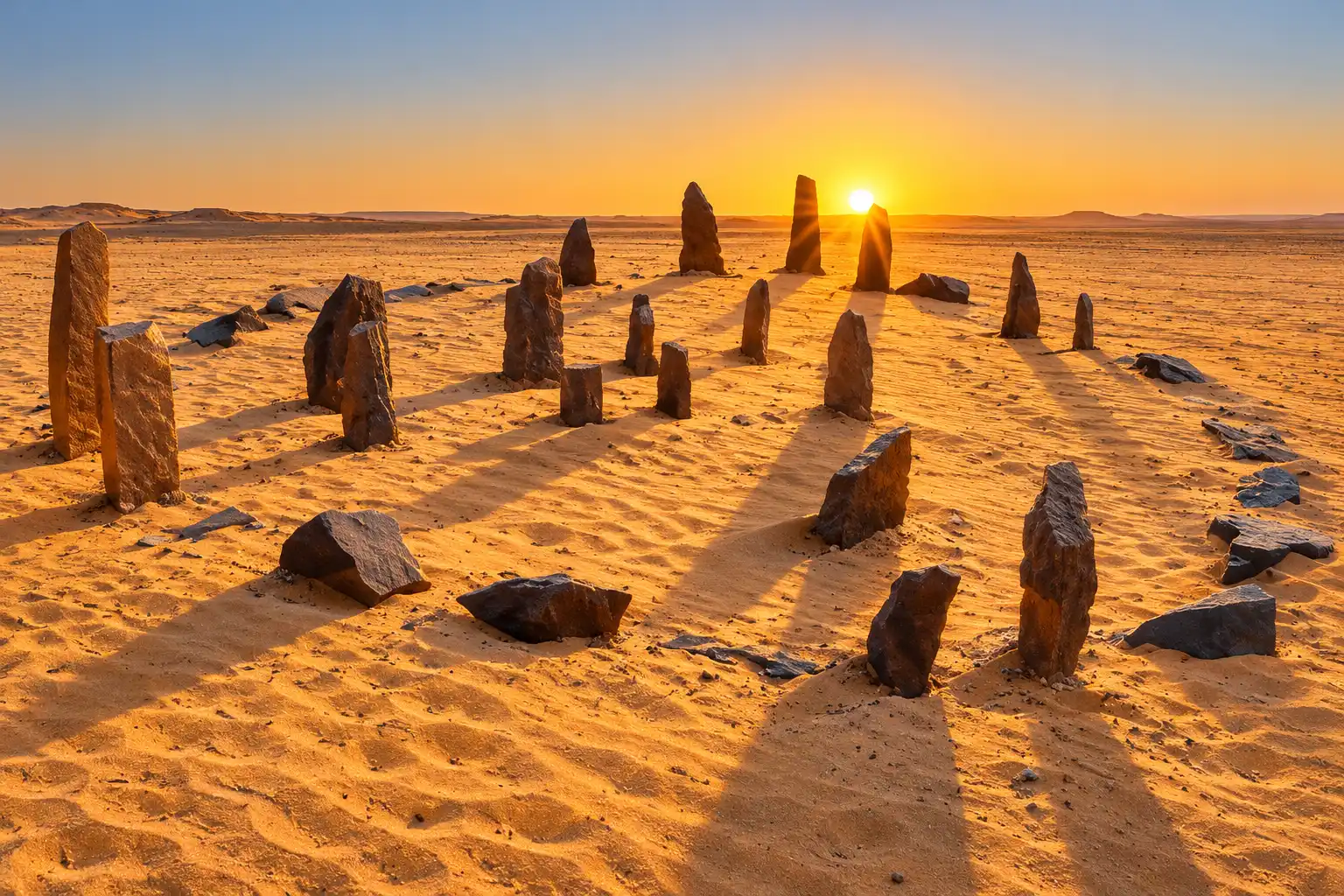
Photographs sometimes make every prehistoric ring look like a cousin of Stonehenge. The calendar circle at Nabta is a setting of small sandstone slabs about 4 meters across, about the width of a modest room, built from local slabs rather than from tall pillars brought in for show.
Layout of the Solstice Gates
Four pairs of larger stones sit in that ring and work as narrow gates, which the Wendorf and Schild field account describes piece by piece. Six more slabs stand in the center in two rows. The gates are the part with a job you can state in ordinary words.
WHAT THE GATES ARE FOR
- North-south gates: Two pairs frame a north-south view, the axis herders used when they crossed open desert.
- Solstice gates: The other two pairs form a line toward sunrise at the summer solstice, close to the season when the monsoon was due.
- Center slabs: Six upright stones make two lines in the middle, and no sky role for them is evident from the layout alone.
- A shadow habit: A Bedouin worker on the dig said people in the desert still set stones like these and read the moving shadow as a rough clock for the day.
Charcoal from a hearth beside the circle gave a lab age of 6,000 years before present, plus or minus 60 years, sample CAMS-17287. The excavators read that hearth as about 4800 BC. The slabs themselves were never dated, so the hearth is the clock for the ring, not a mark cut into the stone.
Limits of the Calendar Circle Nickname
The nickname calendar circle is the excavators’ own, and they undercut it in the same breath. Gaps between the stones in each gate are a bit too wide for a tight sightline, and the gates sit too close together to track the sun’s small shift from one morning to the next.
What the ring can do is coarser, and it is still useful. Sunrise in that gate falls near the start of the rains that refilled the lake. People who met at Nabta in the wet season needed a shared sign that the water was due, not a device that numbered every dawn. Once that limit is clear, the long stone lines south of the ring are the next question, because those are the lines people match to stars.
Star Lines Proposed at Nabta Playa
The circle is the small monument. South of the cattle wadi, the heavy building is a field of more than 30 oval structures made of upright sandstone, each about 5 meters long and 4 meters wide, with one or two large flat slabs in the middle. The group sits on an old beach of the lake.
Those ovals were built over hard lenses of bedrock buried in playa clay. In the largest, the builders shaped the buried rock and set a worked stone of about 2.5 tons over it, a form that resembles a bulky animal from some angles, and the field account calls that piece perhaps the oldest known sculpture in Egypt. The surface ring of stones went up only after the pit was filled.
The only published radiocarbon sample from under one of these structures fell between 5,600 and 5,400 years ago, later than the layering had led the team to expect. Lines of much larger blocks run out from the group across the old lake floor. One north-south row used big quartzite blocks set about 100 meters apart. Other lines have been compared with the rising points of Arcturus, Sirius, Alpha Centauri, and stars in Orion’s Belt.
The dates hung on those lines do not stay still. One row, called the C-line, was first matched to the rising of Sirius, and a later recalculation moved that match much earlier. The excavators’ 2007 reply said those newer dates fell about 1,500 years before the late Neolithic, the time when the large stones went up. On a second look, the C-line stones rest on the sides and tops of dunes, so they may not be a row anyone set on purpose.
| Proposed line | Date attached to it | Where that date stands |
|---|---|---|
| Summer solstice gates | about 4800 BC | Kept by the excavators as a rough direction toward sunrise |
| Sirius on the C-line | about 4820 BC at first, later 6088 BC | The 2007 reply calls the later date about 1,500 years too early and doubts the stones were a built row |
| Arcturus, Alpha Centauri, Orion’s Belt | the fifth millennium BC | Left as possible targets of some lines, not a finished star map |
The same 2007 paper puts the sky evidence in three piles: stones and burials that face north, the solstice gates, and fifth-millennium lines toward bright stars. The authors then say what all of that was for, in a sentence worth hearing whole.
The symbolism embedded in the archaeological record of Nabta Playa in the Fifth Millennium BC is very basic, focussed on issues of major practical importance to the nomads: cattle, water, death, earth, sun and stars.
J. McKim Malville, Romuald Schild, Fred Wendorf and colleagues, 2007
That list is what the fifth-millennium symbolism has to carry. The firmest evidence beside it is the cattle buried north of the circle, animals given a kind of care the ring itself does not show.
Cattle Burials at Nabta Playa
The Young Cow in the Valley of Sacrifices
The clearest rite in the wadi north of the circle is a whole cow, a heavy gift if the herd was food on the hoof as well as a sign of standing. A stone mound about 8 meters across marked the grave.
- The chamber: The young cow lay in a pit cut into the wadi floor, closed with a clay collar and a roof of tamarisk.
- The other mounds: Seven more held cattle bones set among the stones, and none of those seven had an underground chamber.
- Other animals: Offerings along the same valley also included goats and sheep, so the gifts were not cattle alone.
A piece of the tamarisk roof dated to 6,470 years before present, plus or minus 270 years. The excavators calibrate that timber to between 7,400 and 7,300 years ago. The valley is the place the team calls the Valley of Sacrifices, and its position, where water once ran into the lake, is one reason they connect the offerings with rites aimed at rain.
Saharan Herders and Early Egypt
The clay-lined, roofed chambers belong to a late Neolithic group with tighter organization than the earlier camps. Giving up a cow meant giving up milk, blood, and the standing the animal carried. The field account sets that habit next to later African herding life, where cattle are killed for a funeral, a marriage, or the death of a leader, and ordinary meals come from somewhere else.
A direct path from this valley to the goddess Hathor is a suggestion that general accounts often repeat. Hathor was shown as a cow and was linked with protection out in the desert. The claim in the field account is wider: a great deal of political and ritual life in prehistoric Egypt and the Old Kingdom carries the mark of Saharan cattle herders. Nabta is the desert side of that argument, written in graves and seasonal meetings.
The Nabta Playa Stones in Aswan
All of that still lay in the open desert through the 1990s. It does not lie there in the same arrangement now. After the alignment study was published in 1998, visitors who could reach the basin used the printed coordinates, marked the stones, and stood fallen slabs back up, which changed the lines the survey had measured.
“They ended up messing up the area, which had been pristine for 5,000 years,” says J. McKim Malville, the astronomer who worked on those alignments.
Egyptian antiquities authorities later lifted the circle and other large stones. The reconstruction, shown with the expedition’s stelae and presented as a solar calendar, stands outdoors at the Nubian Museum in Aswan. The museum opened in 1997 to house the archaeological record of Nubia after the UNESCO campaign to save monuments from the lake behind the dam, and the garden already works as an open-air display of stonework, an old cemetery, and a channel standing in for the Nile.
IF YOU ARE GOING TO SEE THE RING
- The circle: Look for a small rebuilt ring of slabs in the museum grounds, a few paces across, not a field of tall pillars.
- The stelae: Larger stones from the basin are shown with that ring, so the circle is not the only Nabta object on the grounds.
- The desert: The original layout is no longer there to walk. The pieces that carried the lines were lifted, and some had already been reset by visitors.
Aswan is the practical trip. Abu Simbel is the famous temple far south of the city, and the playa is a further desert crossing west of those cliffs, not a stop on the usual temple day. If the solstice ring is the thing you want to see, the museum grounds are where it stands.
Frequently Asked Questions
Is Nabta Playa Older Than Stonehenge?
The calendar circle is older than Stonehenge’s first stage of building. The Nabta ring is placed at about 4800 BC, while Stonehenge’s early work comes later and then keeps being rebuilt for a long span of centuries. The lake basin was already a meeting place before that ring existed, so the camp is older than the monument people put in the headline.
What Did a UNESCO Inventory Say About Nabta Playa?
An inventory of Egyptian sky-related sites, prepared for the UNESCO World Heritage Convention, described Nabta Playa as having hypothetical solar and stellar alignments. The word hypothetical is doing real work. It leaves the solstice gates and the star lines in the possible column, next to other Egyptian monuments with proposed links to the sky.
Who Was Buried Near Nabta Playa?
The human graves linked to this community are at Gebel Ramlah, a cemetery near the basin, rather than under the calendar circle. Teeth from those skeletons show both Mediterranean and sub-Saharan traits. Bones from Nabta itself point mainly to affinities south of the Sahara, with some North African features mixed in.
What Language Might Nabta Playa’s Herders Have Spoken?
No inscription at Nabta records a language. Christopher Ehret has argued that people of the wider region were Nilo-Saharan speakers, tying that idea to their tools and pottery rather than to any text. Other scholars do not treat the language as settled, and the camps, herds, and stones can be described without picking a language family.
Did the Nabta Playa Stones Map Orion?
Thomas G. Brophy’s Orion reading is not the view of the team that dug the site. He reads three of the inner stones as Orion’s Belt and has offered a second match around 16500 BC, far older than the late Neolithic age of the stones. The excavators leave the six central slabs without a clear sky function, and they set aside star dates that fall before the stones’ archaeological age.
In Aswan the rebuilt ring is about 4 meters across, with openings toward the north and toward summer sunrise. Cattle mounds and buried stone ovals belong to the same seasonal ground. The star lines are the part the original survey team still marks as unfinished.

Cook Hands Democrats the House as Crypto’s Bill Stays Dead

Wicker’s Broken Bed Was the Short Story’s Punch Line

Nvidia’s $500 Billion Financing Plan Draws a $180 Sell

Maserati Bets the Grecale V6 Can Fill Porsche’s Gap

EV Cable Theft Follows the Old Railway Copper Playbook

Aramco Crash Kills 14 Two Days After Oil Restart

Salah Captained Egypt to Their First World Cup Win

Zelda’s 40th Switch 2 Ships Without a Zelda Game

Apple Labor Day Deals Hide June’s Memory Price Hike

El Niño Puts Israel’s Needed Winter Rain on a Flood Clock
-
 BUSINESS4 months ago
Aramco Crash Kills 14 Two Days After Oil Restart
-
 NEWS5 months ago
Salah Captained Egypt to Their First World Cup Win
-
 GAMING2 months ago
Zelda’s 40th Switch 2 Ships Without a Zelda Game
-
 NEWS2 months ago
Apple Labor Day Deals Hide June’s Memory Price Hike
-
 NEWS4 months ago
El Niño Puts Israel’s Needed Winter Rain on a Flood Clock
-

 GAMING2 months ago
Palworld 1.0.4 Adds Palpedia Search After the 1.0 Launch
-

 BUSINESS9 months ago
BAE’s 60-Year Saudi Franchise Now Runs Through Taif
-

 NEWS4 months ago
Saudi Visa Routes Split Nigerian Travelers Into Two Speeds