
NEWS
Google Turns Idle Phones Into a Quake Grid in 200 Regions
Google doubled Android Earthquake Alerts to over 200 regions after Panama’s 7.7 quake, turning idle phones into a public warning grid.

Google on October 15 expanded Android Earthquake Alerts from 98 countries and regions to more than 200, naming Panama and Guatemala among the additions. The company said it has sent over one billion of those warnings since 2021, and described the setup as the world’s largest mobile-based earthquake detection network.
Six days earlier, a magnitude 7.7 quake had struck southern Panama. President José Raúl Mulino treated the Android switch-on as public-safety news the same afternoon Google posted its blog. The extra regions get a warning grid they did not have to fund. They also inherit a system that listens through phones sitting still, and a richer Be Ready map that Google says is still months away.
A Coverage Map That More Than Doubled
Boone Spooner, group product manager for Earthquake Alerts, wrote that a few seconds of warning can be enough time to take cover. Google, he said, built the Android Earthquake Alerts System to deliver that warning at scale. The October 15 post said the company is expanding the system from 98 countries and regions to more than 200, including Panama, Guatemala, “and many more.”
The new regions start getting alerts from October 15, with full availability expected over the following week. Google did not publish a complete list of the added places in the blog, and pointed readers to a separate page that shows where the system is on.
Sundar Pichai, chief executive of Google and Alphabet, tied the expansion to quakes in Venezuela earlier in 2026. He wrote that millions of people outside the epicenter got alerts and could take cover before the shaking began.
Since launching in 2021, our Android Earthquake Alerts System has sent 1B+ alerts. Now we’re expanding the system from 98 to nearly 200 countries and regions.
Proud how this technology can help in moments that really matter. As one example, when the devastating earthquakes hit…
— Sundar Pichai (@sundarpichai) October 15, 2026
THE ALERT SYSTEM, DATE BY DATE
- 2021: Google launches Android Earthquake Alerts after building a phone-based detection network.
- July 17, 2025: A Science paper reports alerts in 98 countries and a reach of 2.5 billion people.
- June 2026: Pichai later cites Venezuela quakes as a case where millions outside the epicenter got warning time.
- October 9, 2026: A magnitude 7.7 quake hits southern Panama at 12:56 p.m. local time.
- October 15, 2026: Google more than doubles the alert map and begins a week-long rollout.
That sequence is the point of the product news. The coverage number moved because the company flipped the feature on in places that were already full of Android phones, not because it poured new seismometers into the ground.
The Phones on the Nightstand Do the Listening
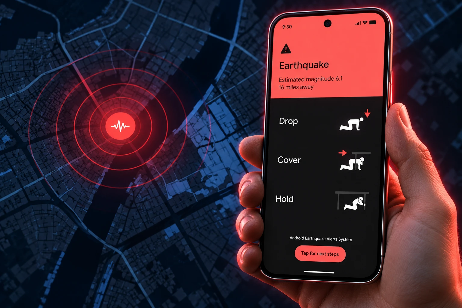
Every Android phone already has a tiny accelerometer, the same chip that turns the screen when you rotate it. When the handset has been still for a while, that chip can pick up the first seismic waves. Google’s servers then look at coarse locations from many phones at once. If the pattern matches an earthquake, alerts go out ahead of the slower, more damaging shaking.
The race is physics, not magic. Phone signals travel far faster than seismic waves, so a cluster of still handsets near the start of a quake can warn people farther out. If you are sitting on the epicenter, your own phone is one of the sensors, and the warning may not beat the shaking. Google has said the feature is on by default on compatible phones, and that it can miss some quakes or arrive during or after the motion.
Older notes from the project team said charging, unused phones make the best mini seismometers, because they are still and the extra work does not drain the battery. The 2025 Science paper described monitoring that starts once a phone has been stationary. Either way, a phone in a bag on a moving bus is a weak listener. A phone on a nightstand is a better one.
That is the catch inside the new map. Adding Panama or Guatemala to a list does not plant sensors in the soil. It asks idle Android phones in those places to act as a seismic net. Thin phone density, fewer still handsets, or a lot of iPhones in the mix all shrink what the net can hear. The doubled map is only as good as the phones that happen to be sitting still when the ground moves.
Three Alert Tiers, and a Map Still Months Out
Users in an active region can get one of three alerts, ranked by the shaking Google expects at that spot. The middle tier, Be Ready, is the one Google is rebuilding. The rebuild is not part of the October 15 region switch. Spooner wrote that the extra details arrive in the coming months.
THE THREE ALERT TIERS
| Alert | Expected shaking | What you see |
|---|---|---|
| Be Aware | Light | A standard notice that a quake was detected nearby |
| Be Ready | Stronger | A detailed prompt to prepare; a map and magnitude still months out |
| Take Action | Moderate to heavy | A full-screen warning with immediate safety advice |
The future Be Ready card is supposed to add a map of the radius where shaking was detected, a magnitude estimate, a suggested action, and a button for more detail as it comes in. Until that ships, people in the new regions get the older, thinner notice: a quake is nearby, shaking is coming, drop, cover, and hold. Google has also said initial magnitude and intensity figures can differ from later scientific readings.
Take Action is the loud one. It can fill the screen, play a distinct sound, and ignore Do Not Disturb. Be Aware is closer to an ordinary notification. The split matters in the new countries, where many users will see this for the first time during a real event, not a drill.
Most Alerts Arrived Before or During Shaking
The strongest public test of the system is still the Science paper from July 17, 2025, led by Richard M. Allen, with Google engineers including Marc Stogaitis and Boone Spooner among the authors. Over three years, the Android network detected an average of 312 earthquakes a month, from magnitude 1.9 up to 7.8 in Türkiye. Alerts went out in 98 countries for quakes of magnitude 4.5 and above, about 60 events and 18 million alerts a month.
WHAT THE 2025 PAPER COUNTED
- People in range: 2.5 billion could receive alerts when the map still covered 98 countries.
- Who felt it: 85 percent of people who got an alert said they felt shaking.
- Timing: User feedback found 36 percent got the alert before shaking, 28 percent during, and 23 percent after.
- False alarms: 3 false alerts in 1,279 events that triggered warnings, two from thunderstorms and one from a mass notification that made many phones vibrate.
The editor’s summary of that paper said phone-based alerts had raised total warning-system access tenfold, to 2.5 billion people, in three years. That was the 98-country era. Google has not published a new population figure for the jump past 200 regions, so the 2.5 billion figure stays tied to the older map.
The one billion alert total in the October 15 blog is a later, cumulative count. It is not the same number as the paper’s 18 million alerts a month. The paper also found that people near the epicenter often cannot be warned in time, because their phones are among the first sensors. Speed and accuracy pull in opposite directions: wait for more data and the warning shrinks; fire early and the magnitude can be wrong.
Panama Gets a Grid It Did Not Build
The U.S. Geological Survey recorded a magnitude 7.7 quake near Pitaloza Arriba on October 9 at 17:56:06 UTC, 12:56 p.m. local, at a depth of 12.6 km. About 3.4 million people felt moderate to severe shaking, the USGS said. Six days later, Mulino posted that cooperation with Google had put Panama on the Android alert system, a free tool that can warn people before the strongest waves arrive. He called it a way to buy time in a quake, when every second can protect a life.
On several Android phones checked in Panama that afternoon, the setting still said the function was not enabled for the region. Mulino posted at 12:56 p.m.; testers were still seeing the block at 1:29 p.m. That lag matches Google’s own note that the new regions fill in over a week, not in an hour.
The U.S. Embassy in Panama described the switch as a three-way effort after the October 9 quake: U.S. government work with the USGS, coordination with Panama, and collaboration with Google.
The United States and Panama are working together to bring life-saving earthquake early warning technology to the Panamanian people. 🇺🇸🇵🇦
Through U.S. government engagement with @USGS, coordination with Panama, and collaboration with American technology leader @Google, Android…
— U.S. Embassy Panama (@USEmbPAN) October 15, 2026
That is the second-order effect. A president, an embassy, and a geological survey are now pointing at a consumer operating system as earthquake early warning. Panama did not have to buy a national sensor grid to get a phone alert. It also does not control the algorithm, the false-alarm rules, or the timeline for the Be Ready map. Guatemala sits in the same bucket. Neighbors such as Belize, El Salvador, Honduras, and Nicaragua were already on Google’s older list; Panama and Guatemala were the holes the October 15 post chose to name.
Why Japan Does Not Get Android Alerts
Google’s published list of active regions has long left Japan off, and help-community replies say the company stays out because Japan already runs a national phone warning system. The same split exists on the U.S. West Coast, in the opposite direction. In California, Oregon, and Washington, Android does not rely on idle phones alone. It carries alerts powered by ShakeAlert, the USGS early-warning system that uses a dedicated network of seismometers. The USGS has described Android as one of several ways those West Coast alerts reach a phone, alongside Wireless Emergency Alerts and apps such as MyShake.
So the global product is really two products. Where a government already paid for sensors and a legal alert path, Android can ride that path. Where no such path exists, the phones themselves are the network. The October 15 expansion is almost entirely the second kind. It is a private detection stack standing in for public infrastructure, on by default, with coarse location and a Google server in the middle.
That is useful in a country that has just been shaken and has no official seconds-ahead warning. It is also a governance problem hiding in a settings toggle. Emergency managers now share the public’s attention with a full-screen Google card they did not write. If the card is late, quiet, or wrong, the complaint still lands on the government that just celebrated the switch-on.
Check Safety and Emergency on Your Phone
Google says alerts are on by default on compatible Android phones in supported regions. The company still tells people to confirm the switch, keep location on, and stay on Wi-Fi or mobile data. A phone with the setting off, or with Google Location Accuracy off, drops out of both the warning and the detection pool.
HOW TO CONFIRM THE SETTING
- The path: Open Settings, then Safety and emergency, then Earthquake alerts, and make sure the toggle is on.
- The extras: Location services and an internet connection are required for the alert to arrive.
- The limit: Google does not predict quakes. It detects one that has already started and tries to beat the worst shaking.
- The miss: You may get no alert, or one that arrives during or after the motion, depending on distance and how many still phones saw the first waves.
- The list: Coverage is limited to where earthquake alerts are active, and that page is the live record as regions finish the week-long rollout.
iPhone users in the new regions are outside this OS-level net unless their country already has a separate warning system. Wearable alerts were not part of Google’s October 15 post, which was written around Android phones.
Google said the new regions should fill in over the week that started October 15. The map that would make those few seconds easier to read is still listed for the months after that.

Cook Hands Democrats the House as Crypto’s Bill Stays Dead

Wicker’s Broken Bed Was the Short Story’s Punch Line

Nvidia’s $500 Billion Financing Plan Draws a $180 Sell

Maserati Bets the Grecale V6 Can Fill Porsche’s Gap

EV Cable Theft Follows the Old Railway Copper Playbook

Aramco Crash Kills 14 Two Days After Oil Restart

Salah Captained Egypt to Their First World Cup Win

Zelda’s 40th Switch 2 Ships Without a Zelda Game

Apple Labor Day Deals Hide June’s Memory Price Hike

Palworld 1.0.4 Adds Palpedia Search After the 1.0 Launch
-
 BUSINESS4 months ago
Aramco Crash Kills 14 Two Days After Oil Restart
-
 NEWS5 months ago
Salah Captained Egypt to Their First World Cup Win
-
 GAMING2 months ago
Zelda’s 40th Switch 2 Ships Without a Zelda Game
-
 NEWS2 months ago
Apple Labor Day Deals Hide June’s Memory Price Hike
-

 NEWS4 months ago
El Niño Puts Israel’s Needed Winter Rain on a Flood Clock
-
 GAMING2 months ago
Palworld 1.0.4 Adds Palpedia Search After the 1.0 Launch
-

 BUSINESS8 months ago
BAE’s 60-Year Saudi Franchise Now Runs Through Taif
-

 BUSINESS8 months ago
Egypt Bets EGP 638 Billion Can Open Sinai to Investors