
Ain Sara still pours from the western slope of Karak at more than 900 metres, watering orchards and cooling the canyon floor while most international itineraries skip straight from Petra to Wadi Rum. Karak Valley, also called Wadi Al Karak, sits in southern Jordan as a working landscape of farms, Roman columns and trail miles rather than a ticketed showpiece.
Jordan recorded over 4.1 million visitor arrivals in 2025. Secondary sites like this one are the practical next layer if the big three cannot absorb every extra bus.
Springs That Still Feed the Valley Floor
The valley drops from the plateau edge of Karak city toward the Dead Sea side. Continuous spring flow, led by Ain Sara, supports diversion ponds, small dams and the crops that locals call a caravan food basket through the year.
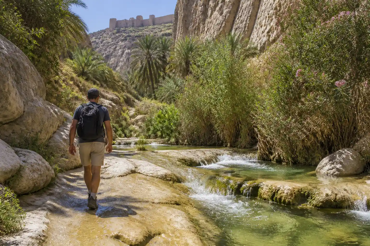
Wild palms, tarfa, oleander and willows line the watercourses. High-temperature mineral pools appear along the course and draw people for simple therapeutic soaks. Waterfalls drop from varying heights and keep the microclimate cooler than the surrounding ridges.
- Ain Sara: main named spring, continuous flow used for irrigation and drinking for centuries
- Elevation source: issues from heights above 900 metres on the western slope
- Vegetation: native trees and greenery that create oasis pockets in an otherwise arid zone
- Local memory: once the place for washing wool before weddings and the “bride’s seat” rock under willow shade
Centenarians still recall the spring as a social hub. Historian notes also record Ottoman-era commander Jamal Pasha ordering its water carried in special containers during World War I after German doctors recommended it. The same water that once served armies now keeps family farms viable.
Layers of Stone From Moab to Mamluk
Karak Castle crowns the plateau above the valley at roughly 900 metres. Construction began around 1142 under the Crusaders. Ayyubids and Mamluks expanded it; Ottomans still garrisoned troops there in the 1890s. The castle’s dark vaulted halls and west wall give views that on clear days reach the Mount of Olives.
Inside the castle the archaeological museum holds material from Neolithic through late Islamic periods, including finds from Bab Adh-Dhra’ and nearby sites. Roman columns stand in the valley itself beside the flowing water, marking earlier engineering that already treated the springs as strategic.
- Moabite and earlier: Iron Age roots and Bronze Age burial links in the wider governorate
- Nabataean-Roman-Byzantine: trade crossroads and architectural remains including columns still visible
- Crusader foundation 1142: fortress begun under Pagan the Butler and King Fulk
- Ayyubid and Mamluk expansion: administrative centre, keep walls and palace additions
- Ottoman garrison: continued military use into the late 19th century
The valley itself carried caravan traffic for centuries. That crossroads role is why Nabataean, Roman and Islamic traces sit so close together.
Where the Jordan Trail Drops Into the Canyons
The long-distance Jordan Trail treats Karak as a major waypoint. The section known as Three Wadis arrives at the castle after days of steep canyon work through Hidan, Mujib and related drainages. From Karak the next region runs south.
The Al-Karak to Dana trail section covers about 84 kilometres over four to five hiking days. Hikers descend into winding valleys with Crusader-era village roots, pass Khirbet Ainun ruins and fertile orchards, then face a thousand-metre drop through Tor al-Taboun limestone before climbing again toward Tafileh and eventually Dana Biosphere Reserve.
Main sites along that stretch include Al-Karak Castle, Tor al Taboun crags, Wadi Hasa, Ma’tan and Buseira Edomite ruins, and Dana Village. The trail is unmarked in places. Local guides are strongly advised because water sources can be limited and mobile coverage drops.
Day hikers shorter on time use the valley floor itself. One described route runs roughly 12 kilometres through varied terrain, streams and waterfalls. Nearby Wadi Bin Hammad offers another water-rich canyon option popular with Jordan-based groups for team outings and moderate canyoning. Adventure travellers on X and local operator feeds treat these southern wadis as reliable water-and-shade days rather than once-in-a-lifetime spectacles.
Farms First, Then Visitors
Agriculture remains the valley’s daily economy. Fertile pockets produce fruits, vegetables and grains for domestic markets and some export. Many families still list farming as primary income. Springs and wells supply the irrigation that makes that possible in a water-scarce country.
Jordan has poured resources into southern water security. Recent FAO work with Spanish funding in Ma’an and Karak built rainwater-harvesting wells and promoted climate-adapted practices for vulnerable rural households. When heavy rains fill reservoirs, stories of Jordan dams reaching full capacity matter directly to places like this that depend on every cubic metre stored or flowing.
Tourism money is welcome but secondary. Efficient spring management is what keeps the orchards competitive and the canyon green enough to photograph. That order of priorities is why local stakeholders treat preservation of flow as non-negotiable.
What Visitors Do on the Ground
Hiking leads the list. Trails suit beginners on the gentler floor sections and stronger walkers on the longer Jordan Trail stages. Designated camping spots let people sleep under clear southern skies. Rock formations support climbing at varied grades, including bolted and traditional routes on nearby cliffs that look west toward the Dead Sea.
Photographers favour the Narrow Siq, a canyon stretch of towering rock walls, and the greenery around the springs. Nature walks turn up native birds and plant variety that the valley’s mixed elevations support. The climate allows outdoor activity across much of the year, with milder seasons preferred for longer treks.
| Attraction | Type | Practical note |
|---|---|---|
| Ain Sara spring | Natural water | Irrigation source and picnic/swim setting |
| Narrow Siq | Canyon hike | Dramatic walls, strong photo light |
| Roman columns | Archaeology | Visible beside flowing water |
| Karak Castle | Fortress and museum | Plateau above, multi-period collections |
| Jordan Trail stages | Long-distance hike | Guide recommended, multi-day |
Cultural programming has grown. The Ministry of Tourism and Karak Municipality run festivals, craft workshops, music and art events. The Karak Cultural Festival brings local and visiting artists. In 2026 Al-Qasr district in the governorate was named a City of Culture, adding more heritage programming near the castle. Educational visits already link the castle museum to school and tour groups.
Infrastructure Pushes and the Balance Point
Authorities list improved visitor facilities, better access roads and more heritage events among future plans. After a royal visit in late 2024 a committee has overseen castle rehabilitation, old-city street work, a handicrafts centre and gate-area projects. The official Karak destination overview already packages the castle plaza, restored Ottoman buildings, restaurants and the archaeological museum for overnight stays.
The same pages flag eco and adventure options: Weidaa slabs for climbing, hiking and abseiling in the valley, and the Jordan Trail connections. That mix is deliberate. Jordan’s tourism strategy needs volume beyond Petra’s slot and Wadi Rum’s camps. Places that already support local livelihoods through water and crops offer a sturdier base than pure scenic stops.
What we know
- Ain Sara and related springs continue to irrigate valley farmland and support vegetation
- Jordan Trail sections treat Karak as a major waypoint with multi-day distances documented
- Castle and museum operate with published seasonal hours and contact numbers
- Cultural festivals and City of Culture designation add programmed reasons to stay overnight
What remains open
- Exact annual visitor counts specific to the valley floor versus the castle alone
- Long-term measured impact of increased foot traffic on spring flow and vegetation
- Pace of new lodging and trail-marking investment relative to demand
Conservation language in local materials stresses tree planting, cleanup and responsible behaviour by both residents and guests. Supporting farm stalls and guides keeps money in the communities that maintain the water systems. The Wadi Al Karak spring and hike details already frame the place as both natural wonder and working landscape.
Why the Quiet Valley Fits the Next Wave
Petra and Wadi Rum will keep the headline numbers. Karak Valley offers something different: a living spring system that still pays local wages, a fortress with a millennium of military architecture, and trail stages that connect the Dead Sea canyons to Dana without requiring a separate logistics base. Day visitors from Amman or the Dead Sea coast can combine the castle museum with a few hours beside running water. Multi-day hikers can treat it as a resupply and rest point on the national trail.
The risk is obvious. More feet and more vehicles raise pressure on the same water that makes the greenery possible. The opportunity is equally clear. A destination that already feeds people can host visitors without inventing an economy from scratch. Jordan’s push toward diversified itineraries gives Karak Valley a larger role if the springs stay protected and the trail stays walkable.
That combination of farm water, layered stone and open trail miles is still under-visited relative to its depth. It will not stay quiet forever if the infrastructure plans land and word spreads among hikers who want shade and history in the same day.
Frequently Asked Questions
Where exactly is Karak Valley located in Jordan?
Karak Valley, or Wadi Al Karak, lies in Karak Governorate in southern Jordan, dropping from the plateau of Karak city on the Kings Highway toward the western slopes that face the Dead Sea basin.
What is the historical significance of Ain Sara spring?
Local tradition links the name to Sarah, wife of Abraham; the spring has irrigated farms for centuries, served as a wool-washing and wedding preparation site, and was noted in Ottoman records when its water was transported for military use in World War I.
How does Karak Valley connect to the Jordan Trail?
It anchors the end of the Three Wadis section and the start of the Al-Karak to Dana region, a roughly 84-kilometre stretch with major elevation change that passes Crusader villages, orchards and Edomite ruins before reaching Dana Biosphere Reserve.
What are the main natural and historical attractions visitors can see?
Beyond Ain Sara and other springs, the valley holds waterfalls, the Narrow Siq canyon, Roman columns beside the water, and the multi-level Karak Castle with its archaeological museum covering periods from Neolithic to Islamic.
Is Karak Valley suitable for beginner hikers?
Shorter floor routes of around 7 to 12 kilometres with limited elevation suit beginners and families in good weather, while full Jordan Trail stages demand fitness, navigation skill and usually a local guide because of remoteness and water logistics.
