
At least 111 people died and dozens more were injured when a magnitude 7.4 earthquake struck western Colombia on Monday morning, collapsing buildings across the coffee heartland and handing brand-new President Abelardo de la Espriella his first national emergency three days after inauguration.
The quake hit at 7:34 a.m. local time near San José del Palmar in Chocó Department. It was felt from Bogotá to Ecuador and Panama. Rescue teams were still pulling survivors from rubble as the toll climbed and aftershocks rattled the region.
Early reports framed a dual crisis: collapsed homes and public buildings in dense coffee-region cities, and slower access to remote communities farther west. The combination left the new government racing the clock on both urban search teams and rural logistics at once.
What the Instruments Recorded
The USGS recorded the 7.4 event at 110 km depth about 5 km from San José del Palmar. It was an intermediate-depth strike-slip rupture inside the subducting Nazca Plate beneath South America. Shaking lasted nearly two minutes in places.
No tsunami warning followed. The Pacific Tsunami Warning Center noted the depth removed that risk. A magnitude 5.0 aftershock arrived roughly 45 minutes later. Community intensity reports reached VIII in spots even as the official ShakeMap peaked near VII.
Approximately 10.5 million people felt strong to very strong shaking (MMI VI-VII). The USGS placed a PAGER orange alert for widespread casualties and economic losses likely under 1 percent of Colombia’s GDP. Vulnerable mud-wall and mixed construction dominates the exposure zone.
Intermediate depth helps explain the wide footprint. Energy traveled farther than a shallow crustal break of the same size usually would, so strong shaking reached cities well beyond the epicenter while peak ground motion stayed below what a surface rupture can deliver. That pattern matches the community reports of long, rolling motion rather than a single sharp jolt.
- Rupture type: strike-slip inside the Nazca Plate
- Depth class: intermediate, about 110 km
- Duration: nearly two minutes in places
- First notable aftershock: magnitude 5.0, about 45 minutes later
The Coffee Triangle Remembers Earlier Shocks
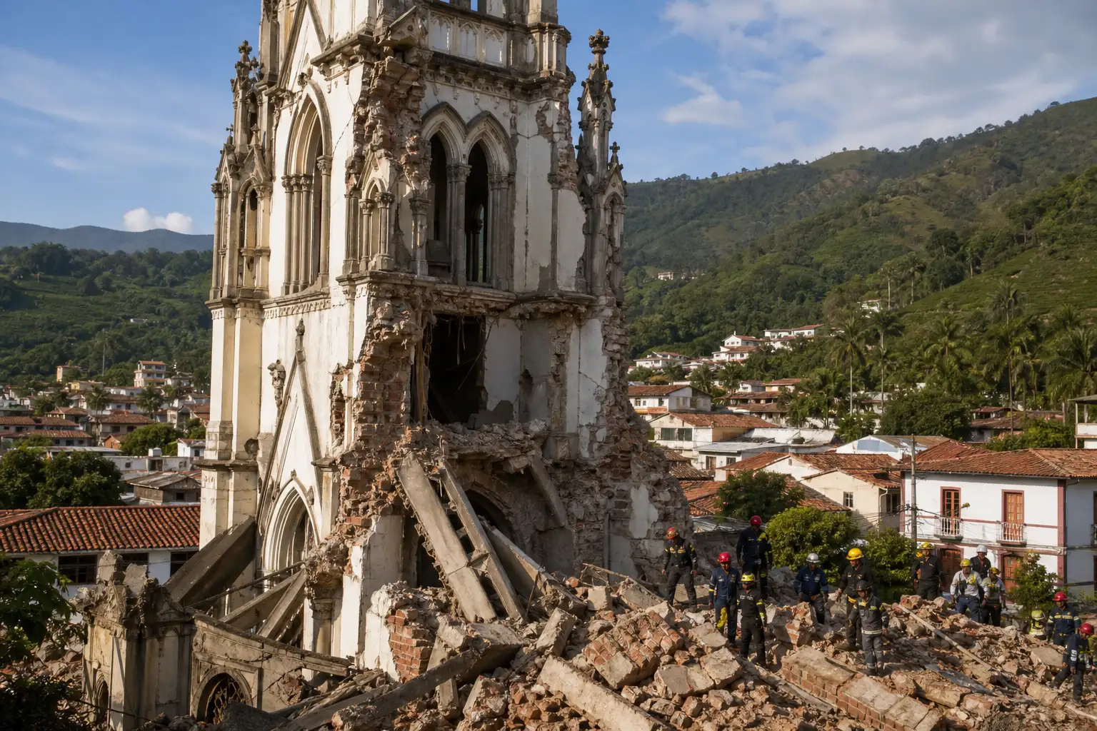
Risaralda, Valle del Cauca, Caldas and Chocó took the heaviest blows. Fatalities clustered in Pereira, Cali, Manizales, Quibdó and Buenaventura. A cathedral tower partially collapsed in Manizales. Homes and smaller commercial buildings pancaked in several towns.
This is familiar ground. The Coffee Axis has been here before.
- 23 November 1979, The El Cairo earthquake, magnitude about 7.2 at similar intermediate depth near the Valle-Chocó border, killed dozens and damaged Manizales, Pereira and nearby towns.
- 25 January 1999, A shallower 6.2 quake near Armenia killed more than 1,100 people, flattened blocks in the coffee region and hammered the national coffee industry for years.
- 8 February 1995, A 6.4 event in Valle del Cauca again struck the same corridor with casualties and structural losses in Cali, Pereira and Armenia.
| Event | Magnitude | Depth character | Noted outcome |
|---|---|---|---|
| El Cairo, 1979 | about 7.2 | Intermediate | Dozens killed; damage in Manizales and Pereira |
| Valle del Cauca, 1995 | 6.4 | Corridor event | Casualties and losses in Cali, Pereira, Armenia |
| Armenia, 1999 | 6.2 | Shallower | More than 1,100 dead; long coffee-industry disruption |
| San José del Palmar, Monday | 7.4 | Intermediate, 110 km | 111 dead in early official tally; wide strong shaking |
Monday’s event ranks among the strongest originating inside Colombia in decades. Intermediate depth usually spreads energy more widely and reduces peak intensity compared with a shallow crustal rupture of the same size. The death toll still climbed because older and informal buildings remain common.
The 1999 comparison is instructive. That quake was smaller and shallower, yet it killed far more people because energy concentrated closer to the surface in a dense urban pocket. Monday’s deeper source spared the region a repeat of that peak intensity while still loading a much larger population with minutes of strong motion.
Damage Numbers Across the West
President de la Espriella reported the early official tally in Bogotá: 111 dead, 87 injured, 1,575 homes damaged, 37 completely destroyed, 61 buildings collapsed, 18 health centers damaged and 52 educational facilities hit. Later local counts in Valle del Cauca alone pointed higher, with hundreds more injured and thousands of homes affected. The national figure remained fluid as remote zones reported in.
| Location / Metric | Detail |
|---|---|
| National deaths (early official) | 111 |
| Injured (early official) | 87 |
| Homes damaged | 1,575+ |
| Buildings collapsed | 61 |
| Pereira (Risaralda) | Heavy damage, early local deaths 18+ |
| Cali / Valle del Cauca | Dozens dead, multiple collapses, trapped residents |
| Manizales | Cathedral tower collapse, structural damage |
| Airports suspended | Pereira, Manizales, Quibdó, Armenia, Cartago, Buenaventura (and reports of Cali restrictions) |
USGS city exposure lists put Pereira, Armenia, Cartago and nearby towns under MMI VII (very strong). Cali and Buenaventura sat in the MMI VI band. Roughly 1.5 million people experienced the strongest shaking tier.
- 10.5 million people in strong-to-very-strong shaking
- Orange PAGER alert signaling potential for regional-to-national response
- Significant landslide and liquefaction exposure flagged by models
- No tsunami threat due to depth
The gap between the early national tally and later Valle del Cauca local counts shows how fluid the picture stayed through the first day. Remote reporting lag in Chocó and uneven hospital intake across departments mean the official numbers were always a floor, not a ceiling, while rubble work continued.
Airports Closed and Roads Cut
Six or more airports halted commercial flights while crews inspected runways and terminals. Matecaña International in Pereira showed damage. Highways suffered at least 18 reported interruptions. Power and water outages hit pockets of the affected departments.
Videos circulating Monday captured the airport terminal in Pereira shaking hard enough to send passengers and staff scrambling. In Cali, debris fell onto medical staff outside a damaged facility. Plaza Bolívar in Pereira filled with dust and fallen masonry as people ran into the open. Those clips matched the pattern of mid-rise and older low-rise failures rather than modern high-rises.
Flight suspensions at Pereira, Manizales, Quibdó, Armenia, Cartago and Buenaventura cut the fastest path for moving search crews and medical supplies between the Coffee Triangle and the coast. Road interruptions compounded that problem on the ground, forcing detours through terrain already flagged for landslide risk.
Utility outages added a second layer. Pockets without power or water slowed both hospital operations and household recovery in the same hours when aftershocks were still arriving. The infrastructure picture, not only the collapsed buildings, shaped how fast help could move.
A President Three Days Into the Job
Abelardo de la Espriella was sworn in on Friday, 7 August, in Cali itself, breaking the Bogotá tradition to signal a hard line on armed groups. By Monday afternoon he was declaring a national natural disaster, activating the full disaster-management apparatus and promising updates every few hours.
“As of 12:30 p.m., we had 111 dead, 87 injured, 1,575 homes damaged, 37 completely destroyed, 61 buildings collapsed, 18 health centers damaged and 52 educational facilities damaged,” he said in his first major public statement. He ordered a unified command post, traveled toward the hardest-hit zones including Quibdó and Cali, and announced rent subsidies and economic aid for Chocó.
International offers of help arrived quickly. Chinese firms already operating in the country began moving heavy equipment toward the wreckage. Domestic military engineers and more than a thousand security personnel deployed to deter looting and support search teams. The new administration’s first test is whether it can coordinate across departments that have long struggled with uneven building enforcement and remote logistics.
Choosing Cali for the inauguration put the new president in one of the cities that would, three days later, report dozens dead and multiple collapses. The symbolic break with Bogotá tradition became an operational fact: the political center of the moment and a major damage zone were the same place.
Aftershocks and the Days Ahead
USGS aftershock forecasts gave a 69 percent chance of at least one magnitude 5+ event within a week and near-certain smaller shocks. Landslide risk remains elevated on steep slopes of the western cordillera, especially after any heavy rain. Liquefaction models flagged extensive areas of soft ground.
Search-and-rescue windows are measured in days. Remote communities in Chocó face slower access than the denser Coffee Triangle cities. Hospitals already damaged will stretch capacity if injured numbers keep rising. Economic secondary effects will hit coffee producers and exporters in Risaralda, Caldas and Quindío even if the direct harvest loss proves modest; the 1999 quake showed how infrastructure and labor disruptions linger.
- Aftershock outlook: 69 percent chance of another magnitude 5+ within a week
- Ground risk: elevated landslides on steep western slopes; liquefaction on soft ground
- Access gap: slower reach into remote Chocó than into Coffee Triangle cities
- Hospital load: damaged facilities facing possible further rises in injuries
Colombia has invested in early-warning systems and updated codes since the 1980s and 1990s disasters. Monday’s losses show how much informal and older stock still sits in high-shaking zones. The same corridor that produces much of the country’s coffee also sits above the northern end of the South American intermediate-depth seismic belt. That geologic fact does not change. Building practice and enforcement do.
De la Espriella’s government now owns the recovery. The death toll will likely climb as rubble is cleared. The political clock started the moment the ground stopped moving.
Building Stock Drove the Human Cost
Instrument readings and damage maps point to the same conclusion. Peak official intensity stayed near VII while community reports touched VIII in spots, yet 61 buildings collapsed and more than 1,500 homes were damaged. The mismatch traces to construction, not to an extreme spike in ground motion.
Vulnerable mud-wall and mixed construction dominates the exposure zone. Mid-rise and older low-rise failures, not modern high-rises, defined the video record from Pereira and Cali. That stock responds poorly to long-duration shaking even when the ShakeMap does not reach the top of the scale.
Codes and early-warning systems have improved since the 1980s and 1990s disasters. Enforcement and replacement of informal housing have not kept equal pace across the same departments that absorbed Monday’s losses. The orange PAGER alert rested in part on that known vulnerability, not on magnitude alone.
Until older and informal buildings leave the highest-shaking tiers, intermediate-depth events in this corridor will keep converting wide moderate intensity into casualties and collapsed public facilities, including the health centers and schools already counted in the early tally.
Coffee Regions Carry a Double Burden
Risaralda, Caldas and Quindío form the core of the national coffee economy and also sit inside the strong-shaking footprint. Roughly 1.5 million people took the strongest tier of motion, including the MMI VII band over Pereira, Armenia and Cartago. Those cities are labor, transport and processing nodes as much as they are residential centers.
Direct harvest loss may prove modest. Secondary effects are less forgiving. Road interruptions, damaged schools and health centers, and displaced workers disrupt the chain that moves coffee from slope to export. The 1999 quake showed how those disruptions linger long after the ground stills.
Chocó adds a different strain. Aid and rent subsidies announced for that department reflect slower access and thinner local capacity, not coffee volume. The national disaster declaration has to cover both the dense Coffee Triangle logistics problem and the remote western access problem at the same time.
Economic losses are still projected under 1 percent of GDP on the PAGER framing. For producers and exporters inside the damaged corridor, the local share of that shock is concentrated, not abstract, and it arrives while aftershocks and landslide risk still limit movement.
The deeper lesson sits in the building stock that failed and the patterns that keep repeating across the same departments. Colombia’s seismic history is long; the next major event will test whatever lessons this one finally locks in place, alongside Colombia’s broader climate and resilience efforts.
