
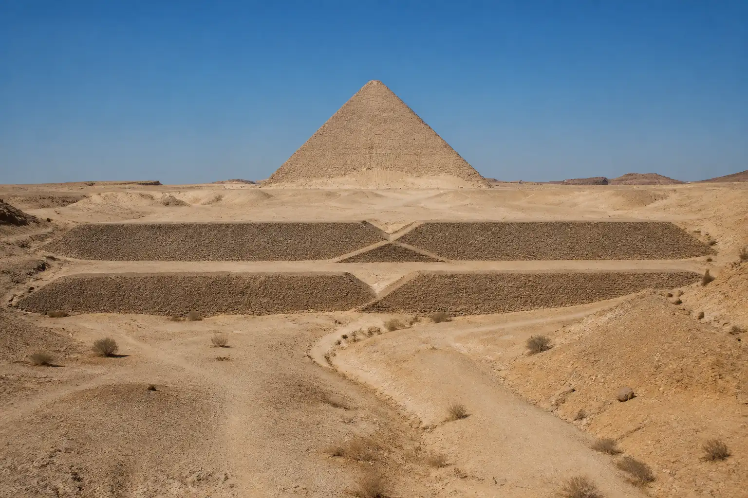
Two long buried formations that cut straight across Wadi Dahshur beside Egypt’s Red Pyramid may be the remains of a two-stage dam system built to trap flash-flood water, drop sediment and feed a diversion canal, according to a July 2026 remote-sensing study. The structures stretch 600 to 700 metres each, stand 6 to 7 metres above the present floor and sit inside a restricted military zone that has never been excavated.
Researchers led by Xavier Landreau of Paleotechnic, Guillaume Piton and Cairo University’s Sayed Hemeda argue the features match embankment dams more closely than the stone-transport roads long assumed by earlier surveyors. The proposal remains unproven until cores, dates and canal connections are recovered on the ground.
What the Formations Look Like Today
The pair crosses the valley southwest of the Red Pyramid, each anchored into opposing slopes with a broad trapezoidal profile 15 to 30 metres wide at the base. Despite thick windblown sand they still rise roughly 6 to 7 metres. Their path blocks the natural drainage line rather than following a logical travel corridor.
Historic maps from Erbkam in 1843, Lepsius in 1855 and De Morgan in 1897 already recorded them. Royal Air Force aerial photographs from 1925 captured both walls clearly. Since 1947 most archaeologists treated the eastern feature as a quarry road and the western one as a natural rise or secondary track.
- Eastern formation: closest to the pyramid, previously read as limestone haul road
- Western formation: farther upstream, sometimes dismissed as a natural ridge
- Central zigzag on the western wall: noted but unexplained under the road model
The new analysis treats that zigzag as the decisive clue.
A Two-Stage System Across the Wadi
The team’s watershed mapping and hydraulic calculations cast the walls as complementary dams roughly 200 metres apart. The upstream western structure would slow flood peaks and drop rock and sand. The eastern wall would retain the clearer water. The basin between them covers about 8.5 hectares and could have held an estimated 61 million gallons.
| Feature | Length | Role in proposal |
|---|---|---|
| Western structure | 600-700 m | Check dam + duckbill spillway |
| Eastern structure | 600-700 m | Main retention dam |
| Intermediate basin | ~8.5 ha / 21 acres | Sediment trap and storage |
| Spillway crest | ~200 m / 656 ft | Doubles overflow capacity vs straight weir |
Satellite and historic air photos show a triangular zigzag section in the western wall. The authors identify it as a duckbill spillway, an overflow form that lengthens the crest and can release more than twice the water of a straight barrier of equal height. No securely documented duckbill of this type is known from earlier Egyptian sites.
- 600-700 m length of each embankment
- 61 million gallons estimated intermediate storage
- More than double the discharge of a straight spillway
Landreau noted the structures would have been broad earth-and-rubble embankments, possibly armoured with stone on the water faces, not modern concrete walls.
Where the Diverted Water Could Have Gone
A long canal already mapped by De Morgan runs roughly parallel to the western face of the Red Pyramid for 600 to 800 metres before turning closer to the monument. One straight section sits about 40 metres above the modern Nile floodplain. Boats could not have sailed straight from the river; materials would still have needed ramps from lower harbours. Once on the plateau, however, small barges or water-lubricated sleds could have moved heavy loads across level ground.
Water could also have served daily needs: drinking for crews and animals, mixing mortar, dust control, and protection of the nearby Bent Pyramid causeway from sudden sediment-laden floods. The researchers stress that water management would have been only one element inside a larger logistics system, not a full explanation of how the pyramid rose.
Hemeda put the claim directly: by engineering the two-stage system they tamed flash floods, stored millions of gallons and redirected water to the construction site, suggesting water served as a primary power and transport aid.
The Earlier Dam That Failed Nearby
The same reign that produced the Red Pyramid also saw the Sadd el-Kafara, an embankment dam on Wadi Garawi less than 20 kilometres east of Dahshur. Built around 2650-2600 BCE and widely regarded as the world’s oldest large dam, it stood about 14 metres high and 110 metres long with a massive earth-and-rock core faced in limestone ashlars. Construction lasted 10 to 12 years. A major flood destroyed the incomplete structure, almost certainly because it lacked an adequate protected spillway.
- ~2650-2600 BCE, Sadd el-Kafara under construction in Wadi Garawi for flood control and quarry water supply
- After 10-12 years, catastrophic flood erodes the unfinished crest and core; work abandoned
- ~2590-2550 BCE, Red Pyramid completed at Dahshur under Snefru; proposed Dahshur dams would fall in the same broad window
The oldest large dam specifications and failure show engineers of the period already understood large-scale flood retention yet still underestimated overflow protection. The Dahshur zigzag, if confirmed as a duckbill, would represent exactly the missing element: extra crest length that lowers peak water levels and reduces overtopping risk. The study itself draws the parallel, noting that the earlier collapse illustrates the danger of insufficient spillway capacity.
Snefru’s building programme therefore appears as a sequence of hydraulic experiments rather than isolated monuments. The Red Pyramid itself was the first successfully completed smooth-sided true pyramid after the Bent Pyramid’s angle change, placing engineering iteration at the centre of the reign.
Wetter Valleys and a Larger Catchment
Today Dahshur is hyper-arid. Early Old Kingdom rainfall in the region is estimated at 50 to 150 millimetres per year, enough for seasonal flash floods in valleys that stayed dry most months. Speleothem and lake records show wetter pulses between roughly 2850 and 2700 BCE. Intense single-day storms could dump 50 millimetres, generating high runoff on silt-rich soils.
Wadi Dahshur’s own local basin is only about 3 square kilometres. The authors point to a flat drainage divide only 80 metres above sea level that could have linked it to western tributaries of the much larger Wadi Taflah catchment, potentially 100 to 400 square kilometres. A short contour canal a few metres wide could have multiplied available water volume many times over without exposing the site to full-basin floods.
The proposed network would never have created a permanent river. It would have turned short, violent floods into a controlled seasonal resource.
What Still Needs Digging
Everything rests on satellite imagery, historical maps, terrain models and hydraulic arithmetic. The site’s military status has blocked excavation. Absolute dates are unknown; the walls could pre-date the Red Pyramid, belong to its construction phase, or post-date it by centuries. Physical connection between the western dam and the diversion canal remains unproven.
What we know
- Two long embankments cut across the active drainage path of Wadi Dahshur
- Western wall contains a zigzag section consistent with a duckbill spillway
- A regular canal runs parallel to the Red Pyramid’s west face
- Sadd el-Kafara failed in the same broad era for lack of adequate overflow protection
What’s unconfirmed
- Construction date of either wall relative to the Red Pyramid
- Presence of engineered cores, erosion armour or water-laid sediments
- Functional link between the western structure and the diversion canal
- Whether the system ever held the calculated volumes under actual flood regimes
Hesham Hussein of Egypt’s Ministry of Tourism and Antiquities said confirmation through excavation could significantly transform understanding of Fourth Dynasty construction logistics. The authors list priority digs: the spillway section, the eastern dam centre, the intermediate basin and the canal junction.
Remote-sensing claims about Egyptian monuments have advanced ahead of ground truth before. The present case is framed explicitly as a proposal that needs field verification.
How the Proposal Sits in the Wider Debate
Pyramid construction theories already range from external earth ramps to internal ramps and counterweight systems. Water-assisted methods have gained fresh attention, including a separate water-powered elevator theory for Djoser at Saqqara. The Dahshur work adds a flood-capture and distribution layer rather than a single lifting device.
Crowd discussion on X has focused on the same tension the authors acknowledge: the remote case is coherent, yet sand cover and access restrictions leave the road-versus-dam question open until someone digs. One widely shared thread noted that a zigzag makes no sense on a haul road yet is standard on spillways, while another stressed that no material from either structure has ever been tested. Those observations track the paper’s own limits.
The npj Heritage Science study abstract presents the first published evidence for giant dams at the site and a water diversion channel west of the Red Pyramid. Whether the walls ultimately prove to be dams, roads or natural features, the Fourth Dynasty already possessed large-scale embankment technology and had paid a high price for incomplete flood control. The Dahshur proposal simply asks whether Snefru’s engineers applied the lesson within sight of the first true pyramid.
Rival explanations for how the later Giza monuments rose continue to multiply; this study inserts an earlier chapter of hydraulic learning into that long argument among rival studies on pyramid construction methods. Excavation will decide if the chapter belongs in the main text or the footnotes.
