Carbonized cereal seeds, pulled from the granary floor of a desert fortress in southern Israel, returned a radiocarbon range of 791 to 772 BCE. That single result, published in the journal Levant on April 27, has dismantled a four-decade consensus that the Assyrian Empire built the two largest Iron Age fortresses in the Arava Valley after crushing the Kingdom of Israel in 732 BCE.
The Israel Antiquities Authority (IAA, the state body that licenses and supervises all archaeological excavation in Israel) team behind the work argues the buildings went up while the Northern Kingdom was still standing, roughly forty years earlier, putting an Israelite administration on the road to Arabia at the height of the eighth century.
The Seeds That Broke the Assyrian Hypothesis
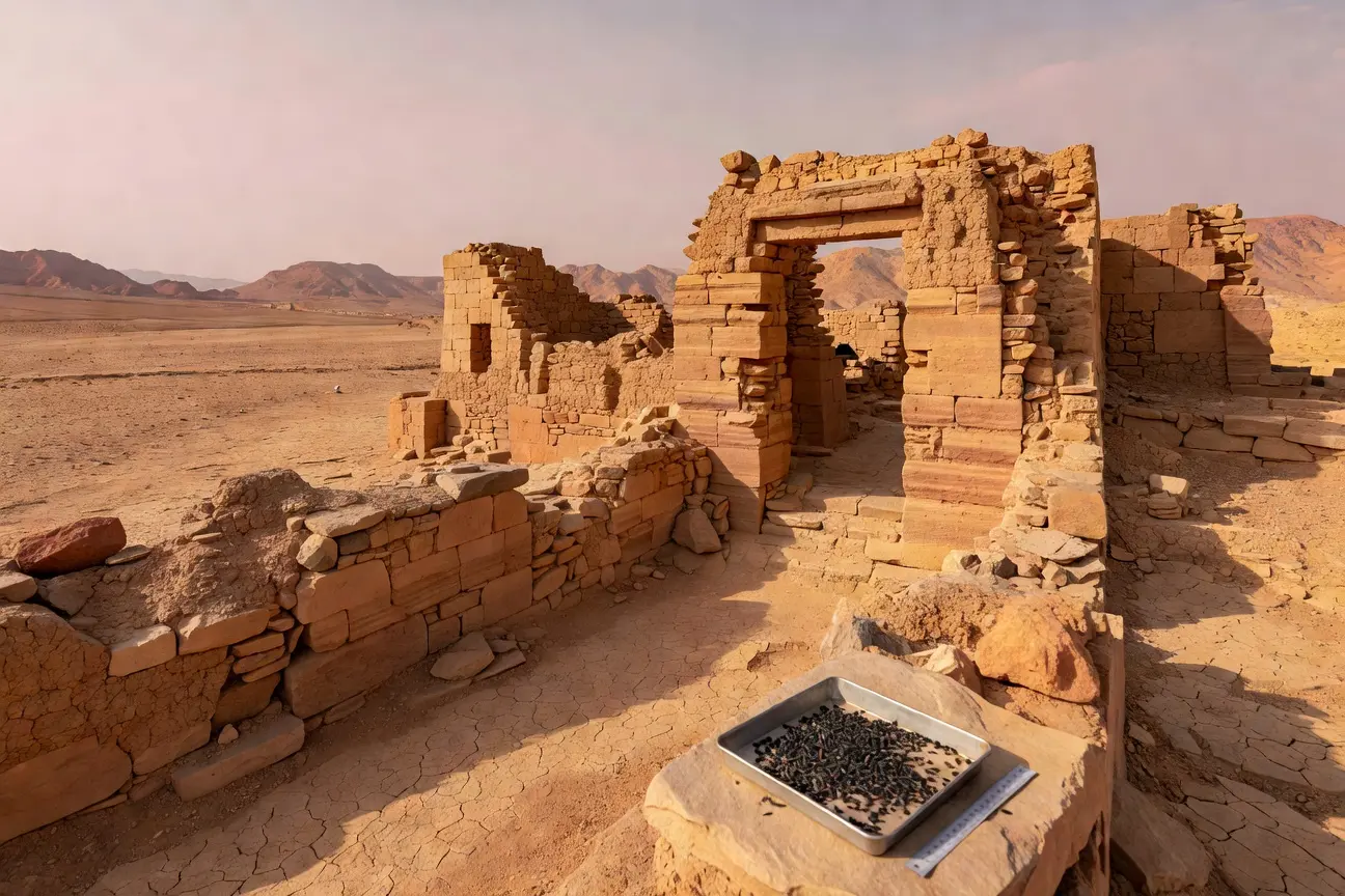
Dr. Doron Ben-Ami, the senior IAA researcher who led the study, sent the granary samples to the D-REAMS Radiocarbon Dating Laboratory at the Weizmann Institute of Science in Rehovot. The first batch came back too clean. Dates fell decades before the long-accepted Assyrian terminus, and the team did not believe its own result.
So more material went to Rehovot. Elisabetta Boaretto, who runs the Weizmann lab and is a co-author on the paper, ran cereal seeds twice from the same sealed context. The duplicate result held. The fortress at Ein Hatzeva, south of the Dead Sea, was operational somewhere between 791 and 772 BCE, well before the Assyrian campaign of 732 closed the curtain on the Northern Kingdom.
This is the beauty of archaeology. For years, you are captivated by a certain hypothesis, even though you do not have the smoking gun, and you try to fit everything in, and then you actually find out you were proceeding in the dark, thanks to a bunch of cereal seeds.
Ben-Ami told The Times of Israel that the structures’ establishment, in his words, “had nothing to do with the Assyrians.” Once the second run confirmed the first, the IAA team accepted that the construction program belonged to a different power entirely.
The pivot is methodological. The previous chronology leaned on architectural typology and ceramic style, both of which carry wide error bars across the Iron Age. Radiocarbon on a sealed grain deposit pins the construction to a calendar window with no comparable ambiguity. Two independent runs on the same context narrow it further.
| Detail | Pre-2026 consensus | New radiocarbon result |
|---|---|---|
| Builder | Assyrian Empire | Kingdom of Israel |
| Approximate construction | After 732 BCE | 791 to 772 BCE |
| Primary dating method | Architectural typology | C14 on granary cereal seeds |
| Strategic purpose | Post-conquest garrison | Live trade-route control |
Two Fortresses, One Hand
The study covers two sites that sit roughly 160 kilometres apart along the same desert spine. Ein Hatzeva, south of the Dead Sea, is the largest known Iron Age fortress in the southern Levant. Tell el-Kheleifeh, just inside modern Jordan, sits about 500 metres from the northern shore of the Gulf of Aqaba, almost equidistant between the modern cities of Aqaba and Eilat.
The team identified architectural fingerprints shared between the two that read as a single design brief, not as parallel improvisation by separate builders working decades apart.
- Casemate fortification walls of matching thickness and bonding pattern
- A four-chambered gatehouse facing the trade road
- Mudbrick modules of consistent dimensions
- Granaries positioned to the same compass orientation
- Pottery in the foundation fills drawn from the same Iron IIA repertoire
“All scholars dealing with these fortresses, including myself, are of the opinion that there was one architect behind the two, and they were constructed at the same time,” the lead author said. The question was never whether a single hand designed both fortresses. The question was always whose hand it belonged to.
Why It Had to Be the Northern Kingdom
Three powers operated within reach of the Arava during the first half of the eighth century BCE. The Kingdom of Judah ruled from Jerusalem under Amaziah and then Uzziah. The Kingdom of Edom sat to the east, in the highlands above the rift. And the Northern Kingdom of Israel ruled from Samaria under Jeroboam II, the longest-reigning monarch of the Israelite north.
Edom had not yet consolidated as a regional power capable of monumental construction. Judah in 791 BCE was rebuilding after Amaziah’s defeat at Beth-shemesh and the sack of Jerusalem that followed, with neither the manpower nor the silver to fund a fortified twin-installation across 160 kilometres of unforgiving desert. That left one candidate, sitting two hundred kilometres north and at the wealthiest point in its history.
“Why Israel? Because most scholars are of the opinion that during this time period, Israel regained hegemony over the region, as documented also in the biblical narrative and based on archaeological evidence,” Ben-Ami told The Times of Israel.
Prof. Israel Finkelstein of the University of Haifa, who was not part of the work, called the result “a very interesting study, which significantly advances the study of the south in particular and the history of ancient Israel (including biblical exegesis) in general.” His own reading goes further. “In the early eighth century, the Northern Kingdom (of Israel) dominated the trade routes in the south, possibly with the help of Judah as a vassal,” Finkelstein assessed.
The vassal-Judah piece is the more contentious half of that reading and will draw pushback from scholars who place Uzziah on a more equal footing with Samaria. The radiocarbon arithmetic on its own does not require it. By 780 BCE, only the Israelite court at Samaria had the manpower, the masons, and the grain reserves to garrison both ends of the Arava simultaneously, which is what the new dates show happened.
The Arava as a Spice Road
The corridor between Hatzeva and Kheleifeh existed to tax the trade running through it, not to defend a frontier. The two fortresses bracket the only practical land route between the southern Levant and the Arabian Peninsula, the same caravan track that would carry frankincense and myrrh from the south Arabian kingdoms into Mediterranean ports for the next eight centuries.
Whoever held both ends held the toll. The northern fortress at Hatzeva controlled the climb out of the Arava toward Beersheba and the Judean lowlands. The southern fortress at Kheleifeh controlled access to the gulf and, through it, the coastal track running south toward the Hejaz. The arrangement is a textbook chokepoint pair: hold the throat at each end, leave the middle to caravan operators.
Recent Saudi-side digs have started filling in the other end of the same corridor. A Bronze Age fortified town beneath the Khaybar oasis shows the southern terminus of the route was already a network of walled settlements long before the Iron Age installations in the Arava went up. The two Israelite forts latch onto a much older Arabian commercial architecture rather than imposing themselves on an empty desert. Whoever ordered them built understood they were entering a market, not creating one.
The economic stakes match the building program. Jeroboam’s reign is the most prosperous phase the Northern Kingdom ever recorded, with grain, oil, and wine moving through Samaria’s storehouses in volumes that show up in the Samaria Ostraca tax receipts. Stacking an Arabian incense tariff on top of that domestic surplus is consistent with the wealth profile in 2 Kings 14, and it arguably explains where some of the surplus came from.
What Nelson Glueck Got Wrong at Kheleifeh
The Assyrian attribution did not appear from nothing. Nelson Glueck, the American rabbi-archaeologist who dug Tell el-Kheleifeh across three seasons between 1938 and 1940, originally identified the mudbrick mound as Solomon’s port of Ezion-Geber. That identification has since collapsed under newer ceramic analysis. The 10th-century BCE date Glueck assigned to the lowest layers does not hold.
The full Kheleifeh excavation reports were never technically published, which left the field dating the site through Glueck’s preliminary notes and field photographs. A 1985 reappraisal by Gary Pratico at the American Schools of Oriental Research walked the chronology down by roughly two centuries, settling the casemate fortress phase in the first half of the eighth century BCE on stylistic grounds. That is the figure the new radiocarbon work has now confirmed, in absolute calendar years, on cereal seeds rather than potsherds.
Hatzeva carried its own gap. The site was excavated and then, in the lead author’s own description, “neglected” for decades despite being the largest Iron Age fort in the southern Levant. Without published, dated, primary samples, the Assyrian-builder hypothesis fed on absence rather than on evidence. The new study fills exactly that gap, with material from the granary floor itself.
A Biblical Verse with a New Receipt
2 Kings 14:25 credits Jeroboam II with restoring the borders of Israel “from Lebo-hamath to the Sea of the Arabah.” The Sea of the Arabah is the Dead Sea, and the verse implies political reach down the Arava rift toward the gulf. Critical scholarship has spent most of the past century treating that line as theologically motivated geography, written long after the fact to flatter a dynasty. The new dates do not prove the verse, but they remove the easiest reason to disbelieve it.
The agreement opens the next question. How many other Iron Age sites in the Negev, currently catalogued as Assyrian, Edomite, or Judahite, are misattributed because they were dated by typology rather than by absolute samples? If even a third of those redatings move in the same direction as Hatzeva and Kheleifeh, the eighth-century map of the southern Levant gets rewritten in favour of a northern monarchy whose reach historians have spent a generation trimming back. That redrawing starts with a handful of charred seeds in a Rehovot lab.