Saudi Arabia is rethinking what grows from its soil. As food security pressures rise and water stays scarce, scientists and planners are looking down, literally, to map what lies beneath the surface and figure out how farming can still work across a tough landscape.
The ground beneath Saudi Arabia tells very different stories
Across Saudi Arabia, soil is anything but uniform. One region crumbles into sand, another hardens into rock, while valleys quietly collect nutrients over centuries. This patchwork shapes farming far more than most people realize.
In Riyadh, soil scientists describe the Kingdom as dominated by sandy desert soils, especially across central and eastern areas. These soils drain water quickly and struggle to hold nutrients, which makes traditional farming difficult without support.
Move toward the highlands and things change again. Rocky and stony soils dominate mountainous areas, limiting root growth and mechanized farming.
Then there are the wadis.
These valleys, carved by ancient water flows, collect alluvial soils that are far richer than their surroundings. Historically, they supported date palms and seasonal crops, long before modern irrigation arrived.
Soil diversity here is not an academic detail. It decides whether a seed survives.
Salt, sand, and limestone shape what can grow
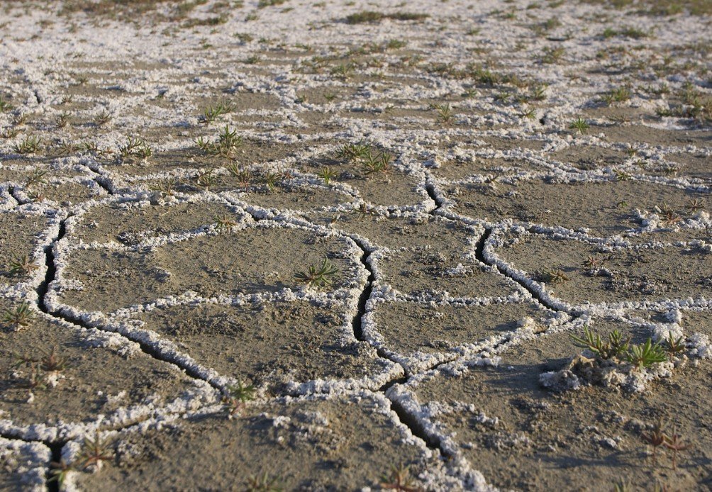
Some of the most challenging soils are also the most widespread. Saline and sodic soils stretch across coastal zones and sabkhas, where salt accumulates near the surface.
High salinity can block plant roots from absorbing water, even when moisture is present. Crops may look green one week and wilt the next, basically starved by chemistry rather than drought.
Central regions are also heavy in calcareous soils, rich in calcium carbonate. These soils raise pH levels, locking away nutrients like iron and zinc.
Farmers face trade-offs every season.
One soil expert summed it up simply. Soil can look fertile and still fail crops because chemistry, structure, and water behavior all matter at once.
That is why soil mapping has become more than a research exercise. It is a planning tool.
Why soil mapping matters for modern agriculture
Saudi Arabia’s push for smarter agriculture depends on knowing exactly what sits beneath each field. Without that data, projects waste water, fertilizer, and time.
Specialists working with the National Afforestation Center, part of the National Center for Vegetation Cover Development and Combating Desertification, say soil classification helps match crops to land rather than forcing land to fit crops.
One senior environmental specialist explained that soil acts as more than a base. It stabilizes roots, supplies nutrients, and even works as a communication medium between plants and microbes.
That function varies wildly across regions.
In practical terms, soil mapping helps decision-makers choose:
-
Which crops suit sandy soils with fast drainage
-
Where salt-tolerant plants are necessary near coasts
-
Which wadis can support long-term tree cultivation
One sentence matters here.
Wrong soil choices raise costs and lower yields, fast.
Mapping also guides intervention. Soil amendments, organic matter, gypsum for saline soils, and controlled irrigation can turn marginal land into productive ground, but only if planners know what they are treating.
Different crops, different soil needs
One common mistake is treating soil fertility as a yes-or-no question. Experts argue that is outdated thinking.
Trees, for example, need deeper, more stable soils than ornamental plants. Root crops demand loose structures. Aquatic plants follow entirely different rules.
A soil lead at an international engineering consultancy said soil suitability always depends on use, not labels. Fertile for one plant can be useless for another.
Date palms thrive in sandy soils with proper water access. Coastal plants tolerate salt. Certain grasses survive limestone-heavy ground where vegetables fail.
This flexibility is shaping newer agricultural models in the Kingdom.
Instead of importing crop systems wholesale, planners are adapting them. Local soil decides the crop, not the other way around.
That shift sounds obvious. It is not how farming here worked for decades.
Soil science meets food security goals
Saudi Arabia imports a large share of its food. That reality pushes authorities to squeeze more value from domestic land without draining aquifers.
Soil mapping feeds directly into that strategy.
By identifying where crops can succeed naturally, planners reduce dependence on heavy irrigation and chemical fixes. Over time, that approach lowers costs and environmental stress.
There is also a climate angle.
Healthy soils store carbon, support vegetation cover, and reduce erosion. In a country battling desertification, soil health links straight to environmental stability.
Government-backed studies increasingly treat soil as infrastructure, not dirt.
That framing is changing budgets, research priorities, and land-use planning.
A quiet shift with long-term impact
This work rarely makes headlines. There are no ribbon cuttings or flashy announcements. Soil surveys happen slowly, grid by grid.
Yet their impact stretches decades.
A mapped field today shapes what farmers plant ten years from now. It decides which rural areas stay productive and which fade.
In interviews published by Arab News, specialists stress patience. Soil improvement takes time. Some fixes show results in seasons, others in generations.